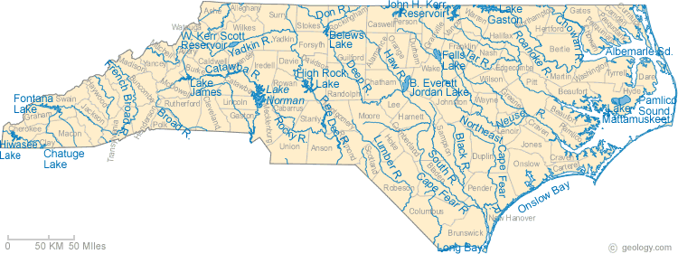
Our State Geography in a Snap: bodies of water
by Emily Horton
NC Government & Heritage Library, 2012.
See also: Rivers; Lakes; Sounds
Ocean
The Atlantic Ocean forms the border of eastern North Carolina.
Sounds
Albemarle Sound, Back Sound, Bogue Sound, Core Sound, Pamlico Sound
See Also: Sounds
Major rivers
Cape Fear River, Catawba River, French Broad River, Neuse River, New River, Roanoke River, Yadkin Pee-Dee River.
SEE ALSO: EXTENDED ENTRY ON NC RIVERS
Major lakes
Lake Waccamaw (Columbus County), Lake Mattamuskeet (Hyde County), Lake Phelps (Washington, Tyrell County), Lake Gaston (Halifax, Northhampton, Warren County), Jordan Lake (Durham, Wake, Chatham Counties), Lake Norman (Catawba, Iredell, Mecklenburg, Lincoln Counties)
other lakes
Sources:
"Geography of North Carolina," North Carolina Department of Public Instruction, https://www.dpi.nc.gov (accessed March 26, 2012).
"Beaches, Rivers, and Lakes," Visit NC, https://www.visitnc.com/beaches-rivers-lakes (accessed February 2022).
"North Carolina: Facts, Map, and State Symbol," Enchanted Learning, last modified 2010, http://www.enchantedlearning.com/usa/states/northcarolina/ (accessed March 26, 2012).
"North Carolina Geography and Climate," Secretary of State/Kids Page," http://www.secretary.state.nc.us/kidspg/ (accessed March 26, 2012).
The North Carolina Gazetteer by William S. Powell (Chapel Hill: UNC Press, 1968)
Map Credit:
"North Carolina Lake Map, River Map, and Water Resources." Map courtesy of Geology.Com, http://geology.com/lakes-rivers-water/north-carolina.shtml (accessed March 27, 2012).
1 January 2012 | Horton, Emily S.
