Mattamuskeet American Indian Tribe
 The Mattamuskeet American Indians, also known as the Machapunga or Marimiskeet American Indians, inhabited the region of present-day Hyde County at the time of the attempted settlements on Roanoke Island in the 1580s. According to explorer John Lawson, by 1701 the Mattamuskeet/Machapunga were reduced to a single village, called Mattamuskeet, and numbered about 30 warriors (representing a probable total of less than 100 people). The Mattamuskeet were known as expert watermen. They likely became dependent on European trade, as did their neighbors, and in the years prior to the Tuscarora War (1711-13) they undoubtedly witnessed their share of the clashes that were becoming frequent between natives and European settlers. Along with the Bay River tribe and the Pamlico tribe, the Mattamuskeet joined the lower Tuscarora, the Coree, the Woccon, and possibly other tribes, in fighting against European settlers in the Tuscarora War.
Following the war, several remnant tribes, comprised mainly of Mattamuskeets and Corees, were relegated to a Mattamuskeet reservation, an isolated tract of about 36 square miles of marsh and low ridges bordering Lake Mattamuskeet in Hyde County. The Coree evidently did not remain long on the reservation. The tribes occupying the reservation began selling off their land to white settlers as early as 1731, and the final sale, dissolving the reservation, occurred in 1761. Sporadic references to surnames common among these tribes continued to be recorded through the 1800s, and some surnames survive in Hyde County today.
The Mattamuskeet apparently faced constant pressure from white settlers, and in 1724 Mattamuskeet "kings" John Squires and John Mackey petitioned the Colonial Council for their lands to be surveyed and conveyed as a formal grant. The grant was approved in 1727, but the actual survey seems never to have occurred. The tribes had been given 10,240 acres, but in reality they received a considerably larger number of acres in exchange for two buckskins and an annual quitrent of one shilling per 100 acres.
Squires served as chief of the Mattamuskeet from 1718 until his death in the 1740s, apparently residing on a 150-acre tract at the mouth of Mattamuskeet Creek, later renamed Middle Creek. After Squires's death, a leadership struggle appears to have occurred, with power split between several individuals.
Alexander Stewart reported after his 1761 trip to the area that the Roanoke and Hatteras American Indian tribes had joined the Mattamuskeet and were residing with them at that time. Stewart baptized more than 25 American Indian people during his visits in 1761 and 1763. The Mattamuskeet tribe declined in number, and in 1792 the entire reservation was sold for £50 to a white settler. That deed was signed by four adult females and three children.
By the early 1800s, apprentice bonds revealed that Mattamuskeet youth were being taught trades by white masters. Afterward the remaining individuals with surnames from the Mattamuskeet tribe were frequently referred to as "free persons of color" and apprenticed as such and also listed in the Hyde County census records under that classification. Even today, some Hyde County families-including the Collins, Barber, Chance, Clayton, and Bryant families-can trace their American Indian heritage back to the Mattamuskeet.
References:
Patrick H. Garrow, The Mattamuskeet Documents: A Study in Social History (1975).
Douglas L. Rights, The American Indian in North Carolina (1947).
John Reed Swanton, The Indians of the Southeastern United States (1946).
Ruth Y. Wetmore, First on the Land: The North Carolina Indians (1975).
Image Credit:
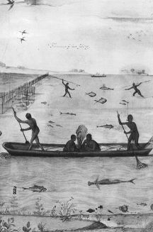
Copy of John White drawing, "Indians Fishing", Large Canoe w/ Fire in center of it; 4 Indians are fishing from the canoe; various types of fish are shown in the water; in wooden wooden frame w/ glazing." Roanoke Island; 1907. Image courtesy of the North Carolina Museum of History, access #: 1914.235.8.
1 January 2006 | DiNome, William G.; Spencer, R. S., Jr.